M-I traffic management is handled with Car Cards and Waybills. I started with Micro Mark cards, then printed my own custom Car Cards and Waybills to best fit the needs of the railroad.
There are 4 main items on each Car Card: the car’s reporting mark and road number are boldly displayed against a background signifying the car’s color. One or two letters in the right upper corner identifies the AAR car type. This allows nearly instantaneously recognition of a particular car. The Layout industries are limited enough that extensive AAR codes are not needed.

Along with the Car Cards, Waybills are also printed in-house. The typewritten billing information is printed with a blue Andale Mono font with a drop shadow. This helps the type stand out better for legibility and mimics the look of a carbon copy.

Micro Mark bill boxes are fastened to the trim fascia at each switching location with a slot for each track. Extra slots are used to store Bad Order slips and may also be used by crews for temporary storage of cards.

When a train arrives at a location, the conductor can easily tell which cars are to be moved. If the Car Card/Waybill packet is facing outward toward the aisle, the car is ready to be moved. Conversely, if a card is facing backwards, the conductor knows that the car is to remain and not be picked up.
If all track spots on a given spur are full and a car is unable to be dropped, the conductor will set the car out at a convenient location and note the Off-Spot location in the bill box. The next train can then re-spot the car as needed.
Waybills show the town where a car is to be delivered along with the industry to receive it (Consignee). It’s easy for a crew to determine layout locations. It’s more difficult when a car is bound for a station and consignee which exists off layout.
The layout has 4 points at which cars exit the layout bound for other parts of the country. The northernmost point is at the Thomure river transfer boat. Next is the SLSF (Frisco) interchange at Ste. Genevieve. The third and fourth locations are at Derby Jct. The Ste. Genevieve subdivision interchanges with the M-I’s Bonne Terre (BT) subdivision at Derby Jct. The lead and mineral mines on the BT sub generate a lot of traffic moving northward/eastward across the river. Cars interchanging with the MoPac are also located here (these are denoted by BISMARCK in the Route section of the Waybill).
Here’s a quick overview of how crews will determine where a car goes off-layout. The Waybill’s Route section will contain one of 4 different entries specifying the interchange point. For example, a car bound off-layout for Centralia, Illinois, will move across the river on the ferry boat. Therefore, its Waybill will have BOAT entered in the Route space. Other possible entries are SLSF, BT SUB and BISMARCK.

When a car is found to be defective (eg, broken coupler, missing ladder/step, derailing frequently, etc), the crew should pink-tag the car with a Bad Order card slipped into Car Card pocket. These are available at all switching locations.
Dangerous loads, such as fuel in tank cars, should not be entrained adjacent to a locomotive or a caboose. The Waybill for these loads contains a bold notice of DANGEROUS CARGO printed in red. This alerts the Yardmaster or train crew that there must be at least one car in between this car and a locomotive, caboose or passenger carriage.
Train orders (Form 19) are slipped into Engine Cards to aid crews in carrying out their switching duties. Form 19 will also give the operator the maximum tonnage of their train and whether a caboose is required. Locomotives are selected on individual throttles using the DCC address specified on each Engine Card.
An Employee Time Table may also be found in the Caboose Card.

Aids for Operators
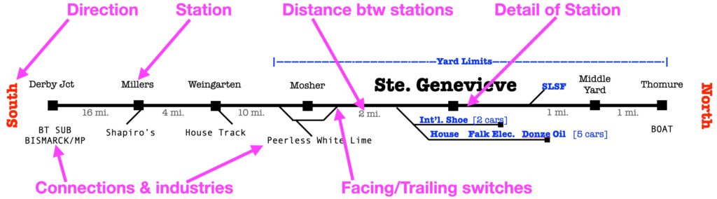
Additional visual aids are placed along the layout for situational awareness. The following example shows distances between towns, the track plan, facing/trailing switches, industry names, directions, and interchange points…
New Operator’s Primer
The M-I layout represents a single subdivision (total of 43 miles in length). Therefore, cars are rarely moved from one industry to another on the layout. Most car movements involve entering or exiting the layout through various points. New operators who are not familiar with the layout geography may be unaware as to what cities/stations are on the layout and which are off-layout. This primer will help eliminate confusion.
The first step is to glance at the car’s Waybill – if the third line (the Route field) is blank, then the the top field (To) destination is guaranteed to be on the layout and will be one of five (5) station locations. Therefore, this car will end up in one of the following locations: Ste. Genevieve, Mosher, Weingarten, Millers or Derby Jct.
If the Route field has an entry, then IGNORE the To field designation. Send the car per its Route entry to one of four locations on the layout for interchange (SLSF, BISMARCK, BT SUB, or the BOAT).

The second field (Consignee) is the name of the specific industry to receive the car. Examples include Peerless White Lime Co., Shapiro Brothers Scrap Metal, Falk Electric Supply, etc. There are times when an industry is listed with an abbreviation of TM TK or HS TK – these are situations where the car is to be spotted on the location’s Team or House Track. These spots are for businesses which do not have their own industrial spur.
So, what are these Route designators and what is their purpose?
- BOAT means the car is to be loaded on the ferry boat crossing the Mississippi River into Illinois (located at the far north end of the layout past Thomure yard)
- SLSF is the interchange with the Frisco railroad and located on a spur just south of the Ste. Genevieve depot
- BT SUB is the M-I’s Bonne Terre subdivision which runs north of my sub and is switched using the interchange tracks at Derby Jct
- BISMARCK is the prototype’s end of the line where it connects with the Missouri Pacific; on my layout, Bismarck is not modeled and is off-layout; it’s treated as an imaginary station. The crew completes set-outs and pick-ups from Bismarck onto a Derby Jct. spur.
In summary, the geography is quickly learned after a session. To recap the basic north to south line……
- Thomure [BOAT]
- Middle Yard
- Ste. Genevieve [SLSF]
- Mosher
- Weingarten
- Millers
- Derby Jct [BT SUB] [BISMARCK]